Trimble SiteVision is a highly accurate augmented reality system that is ideal for outdoor use. It enables you to interact with your spatial data in the context of the real world. You can visualize and measure positions using GNSS and Augmented Reality technology as you explore the project site.
SiteVision uses GNSS and a device’s camera and requires the SiteVision app running on a Trimble device powered by Windows 10 OS and a Trimble GNSS receiver with tilt sensor technology connected to the device via Bluetooth.
Supported Trimble Devices:
- Trimble TSC7 Controller
- Trimble Ranger® 7 Data Collector
- Spectra® Geospatial Ranger 7 Data Collector
- Trimble T7 Tablet
- Trimble Yuma® 7 Tablet Computer
Supported Trimble GNSS Receivers:
- Trimble R12i GMSS Receover
- Trimble SPS986 GNSS Smart Antenna
SiteVision Features and Benefits
SiteVision enables users to easily understand new designs, existing underground services, and how future landscapes will look over time. SiteVision is the ideal tool for multiple industries including architecture, building construction, civil construction and inspection, residential development, urban transportation and planning, and utility projects.
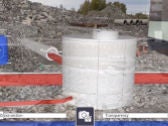
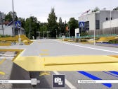
- Place and view georeferenced 3D models from any angle at true-to-life scale—above or below the ground
- Measure positions using GNSS, Electronic Distance Measurement, and Augmented Reality to better understand your data on site
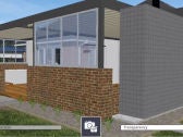
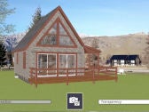
- The transparency slider allows you to see the environment and the design in context at different opacities
- This lightweight handheld model easily travels the entire site—a pole-mounted option is available to accurately position and capture data
- Swappable batteries for better power management and more time in the field
- Integrated Electronic Distance Measurement (EDM) to take accurate measurements on the spot
- Monitor satellite connectivity, accuracy, and orientation on-screen
- Seamlessly integrates with your data from Trimble Business Center, SketchUp, Trimble Novapoint, AutoCAD, and more
Applications
SiteVision plays a key role in all stages of the construction life cycle and allows you to customize the blended augmented reality/real world view based on the data that is most relevant to your task.
- Monitor and conduct quality control for earthworks and paving operations
- Check finished grade and laid material thickness against design elevations and tolerances
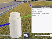
- Confirm designs and avoid issues by identifying the location of utilities in the context of the real world
- Use sub surface mapping information to improve plans by visualizing the location, size and attributes of underground infrastructure such as water, power, gas and telecommunications
- Take photos, record measurements, and make notes in the field for accurate and up-to-date reporting, create and assign tasks to team members.
For more information view the Trimble SiteVision System User Guide.